Augusta Premier Personal
Injury Attorneys

The Most Dangerous Road Segments in Georgia

Motor vehicle crashes are among the leading cause of death and serious injury in Georgia.  Every year, hundreds of thousands of people are involved in collisions throughout the state.

While a collision can occur anywhere, at any time, where are the most dangerous areas for motorists in Georgia?

At Nicholson Revell Personal Injury Attorneys, we wanted to find out.

We worked with data visualization agency 1Point21 Interactive to examine collision data from 2013 – 2020.  We analyzed nearly 3 million collision records to find areas where collisions occur at a higher rate.  In the end, we identified the 12 most dangerous five-mile stretches of road in Georgia.

[Interactive Map]

The map below is interactive.  Zoom in and hover over each stretch to reveal more information.  The 12 most dangerous roads are highlighted in red, while the most dangerous in each region are in blue.  Stretches that are on both lists contain both colors.  If viewing on a mobile device, rotate to landscape mode for the best viewing experience.

The 12 Most Dangerous Road Stretches in Georgia

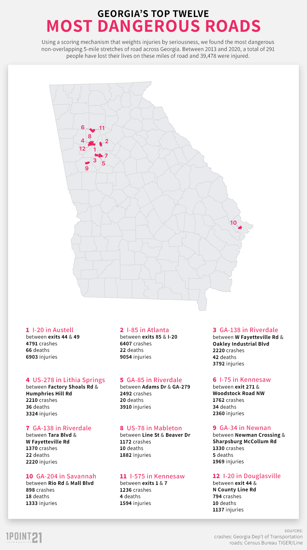
How dangerous are these areas? Consider that there are nearly 90,000 miles of road in the state of Georgia.  During the study period, the 2,984,958 crashes worked out to just over 33 crashes per road mile.  The 12 road stretches that we identified totaled 26,682 crashes – for an average of 445 crashes per road mile.

Of course, roads with significant traffic are most likely to have higher volumes of collisions.  This holds true in our analysis.  In fact, nine of the top twelve road segments that we identified were located in the Atlanta Metro region, while two others were nearby in Newnan and in Douglasville.  Only one stretch was outside this area –  GA – 204 in Savannah – number ten on the list.

The Top Five

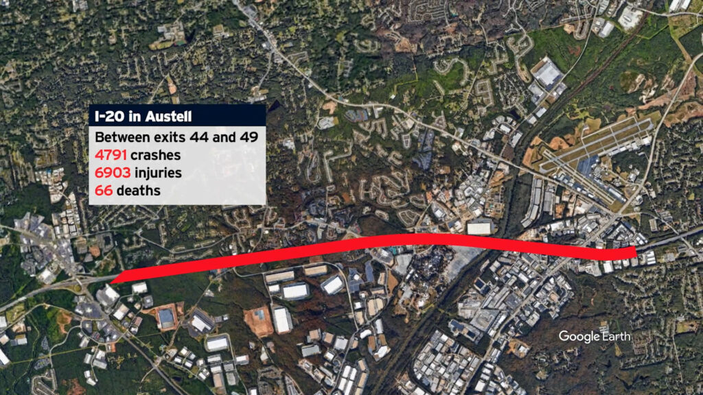
#1. I-20 in Austell

Between exits 44 & 49
4,791 crashes, 66 deaths, and 6,903 injuries

The Most Dangerous Road Stretch in Georgia

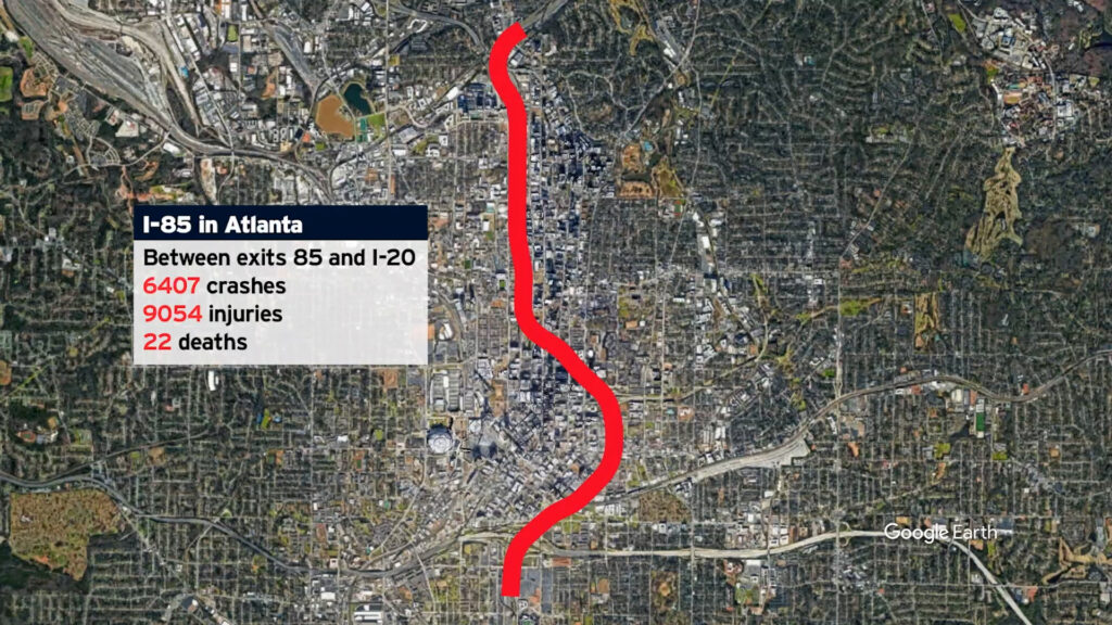
#2. I-85 in Atlanta

Between exits 85 & I-20
6,407 crashes, 22 deaths, 9,054 injuries

The second most dangerous road in Georgia

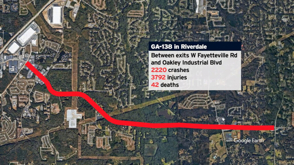
#3. GA-138 in Riverdale

Between W Fayetteville Road & Oakley Industrial Boulevard
2,220 crashes, 42 deaths, and 3,792 injuries

The third most dangerous road in Georgia

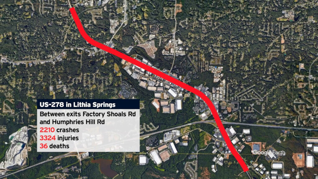
#4. US-278 in Lithia Springs

Between Factory Shoals Road & Humphries Hill Road
2,210 crashes, 36 deaths, and 3,324 injuries

The fourth most dangerous road in Georgia

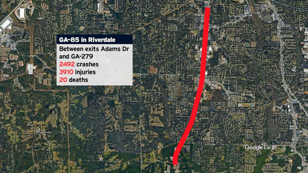
#5. GA-85 in Riverdale

Between Adams Drive & GA 279
2,492 crashes, 20 deaths, and 3,910 injuries

The fifth most dangerous road in Georgia

The Rest of the List: #6 through #12

#6. I-75 in Kennesaw

Between exit 271 & Woodstock Road NW
1,762 crashes, 34 deaths, and 2,360 injuries

#7. GA-138 in Riverdale

Between Tara Boulevard & W. Fayetteville Road
1,370 crashes, 22 deaths, 2,220 injuries

#8. US-78 in Mableton

Between Line Street & Beaver Drive
1,172 crashes, 10 deaths, and 1,882 injuries

#9. GA-34 in Newnan

Between Newman Crossing & Sharpsburg McCollum Road
1,330 crashes, 5 deaths, and 1,969 injuries

#10. GA-204 in Savannah

Between Rio Road & Mall Boulevard
898 crashes, 18 deaths, and 1,333 injuries

#11. I-575 in Kennesaw

Between exits 1 & 7
1,236 crashes, 4 deaths, and 1,594 injuries

#12. I-20 in Douglasville

Between exit 44 & N. County Line Road
794 crashes, 10 deaths, and 1,137 injuries

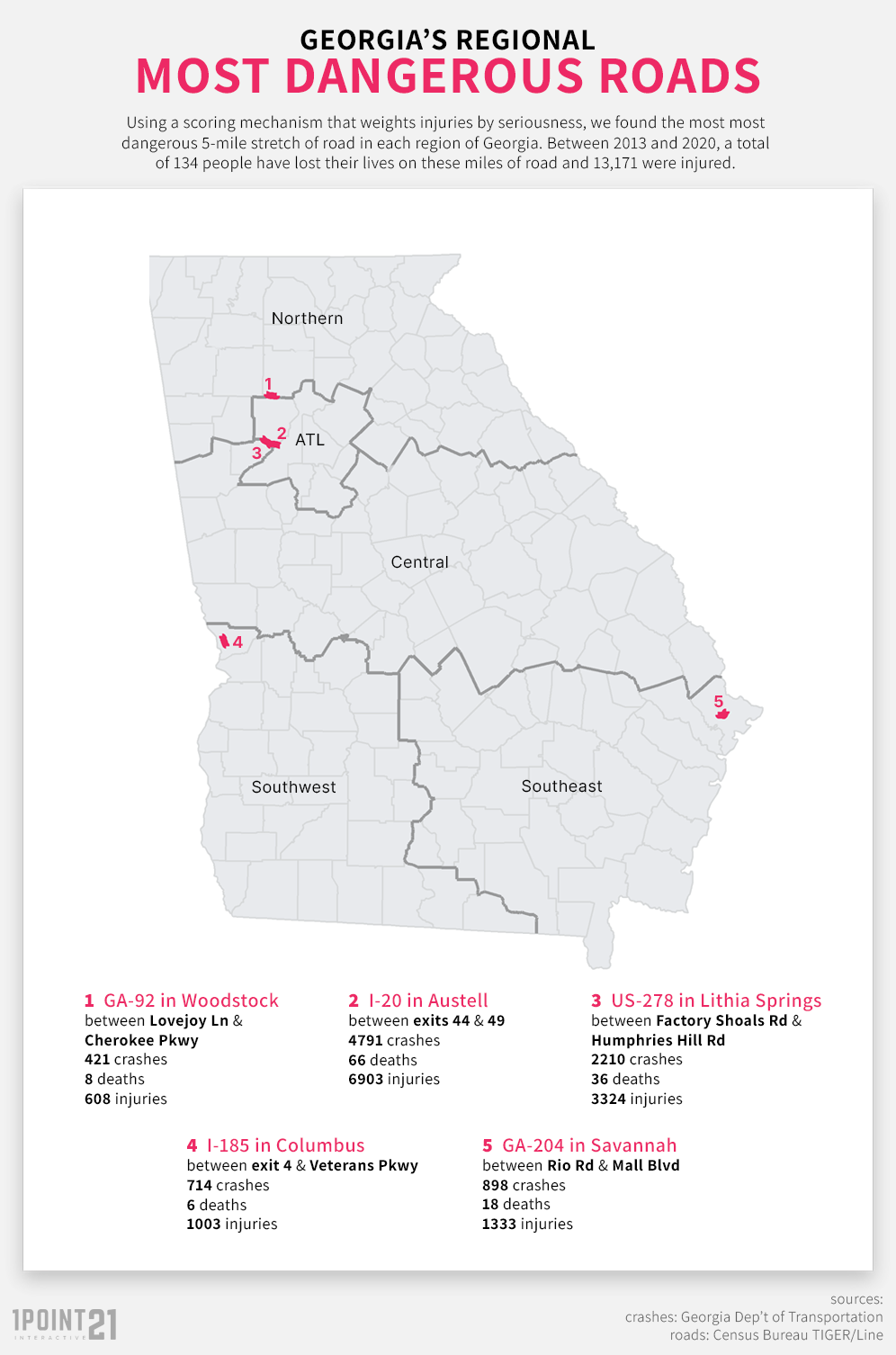
The Most Dangerous Road in Each Region of Georgia

Georgia’s population is growing, nearly 11 million people.  We understand that many of those people are outside of the Atlanta Metro area.  Since so many of our top 12 were in that region, we wanted our list to be useful to all Georgia residents.  Therefore, we also identified the most dangerous stretch in each region of Georgia – Northern, Central, Southwest, Southeast, and – of course – Atlanta.

Northern Region – GA-92 in Woodstock from Lovejoy Lane to Cherokee Parkway

Atlanta Region – I-20 in Austell from exit 44 to 49 

Central Region – US-278 in Lithia Springs from Factory Shoals Road to W Fayetteville Road

Southwest Region – I-185 in Columbus from exit 4 to Veterans Parkway

Southeast Region – GA-204 in Savannah from Rio Road to Mall Boulevard

Methodology and Fair Use

Our study is based on collision records from the years 2013 – 2020, sourced from the Georgia Department of Transportation.  We chose five mile stretches to pinpoint areas that might be especially dangerous for motorists.   Stretches were ranked by crash volume and injury severity.

If you would like to report on our republish the findings of this report or use any image, please link to this page to cite the source.

Call Now Button